
 ,
Thomas W. Swetnam,
Matthew J. Liebmann,
Rachel A. Loehman,
John R. Welch,
Ellis Q. Margolis,
Christopher H. Guiterman,
William C. Hockaday,
Michael J. Aiuvalasit,
Jenna Battillo,
Joshua Farella,
Christopher A. Kiahtipes
,
Thomas W. Swetnam,
Matthew J. Liebmann,
Rachel A. Loehman,
John R. Welch,
Ellis Q. Margolis,
Christopher H. Guiterman,
William C. Hockaday,
Michael J. Aiuvalasit,
Jenna Battillo,
Joshua Farella,
Christopher A. Kiahtipes
Edited by Catherine S. Fowler, University of Nevada, Reno, NV, and approved November 24, 2020 (received for review September 22, 2020)
Author contributions: C.I.R., T.W.S., T.J.F., M.J.L., R.A.L., J.R.W., and E.Q.M. designed research; C.I.R., T.W.S., T.J.F., M.J.L., R.A.L., J.R.W., E.Q.M., C.H.G., W.C.H., M.J.A., J.B., J.F., and C.A.K. performed research; C.I.R., T.W.S., T.J.F., M.J.L., R.A.L., J.R.W., E.Q.M., C.H.G., W.C.H., and J.F. analyzed data; and C.I.R., T.W.S., T.J.F., M.J.L., R.A.L., and J.R.W. wrote the paper.
As residential development continues into flammable landscapes, wildfires increasingly threaten homes, lives, and livelihoods in the so-called “wildland–urban interface,” or WUI. Although this problem seems distinctly modern, Native American communities have lived in WUI contexts for centuries. When carefully considered, the past offers valuable lessons for coexisting with wildfire, climate change, and related challenges. Here we show that ancestors of Native Americans from Jemez Pueblo used ecologically savvy intensive burning and wood collection to make their ancient WUI resistant to climate variability and extreme fire behavior. Learning from the past offers modern WUI communities more options for addressing contemporary fire challenges. Public/private–tribal partnerships for wood and fire management can offer paths forward to restore fire-resilient WUI communities.
The intersection of expanding human development and wildland landscapes—the “wildland–urban interface” or WUI—is one of the most vexing contexts for fire management because it involves complex interacting systems of people and nature. Here, we document the dynamism and stability of an ancient WUI that was apparently sustainable for more than 500 y. We combine ethnography, archaeology, paleoecology, and ecological modeling to infer intensive wood and fire use by Native American ancestors of Jemez Pueblo and the consequences on fire size, fire–climate relationships, and fire intensity. Initial settlement of northern New Mexico by Jemez farmers increased fire activity within an already dynamic landscape that experienced frequent fires. Wood harvesting for domestic fuel and architectural uses and abundant, small, patchy fires created a landscape that burned often but only rarely burned extensively. Depopulation of the forested landscape due to Spanish colonial impacts resulted in a rebound of fuels accompanied by the return of widely spreading, frequent surface fires. The sequence of more than 500 y of perennial small fires and wood collecting followed by frequent “free-range” wildland surface fires made the landscape resistant to extreme fire behavior, even when climate was conducive and surface fires were large. The ancient Jemez WUI offers an alternative model for fire management in modern WUI in the western United States, and possibly other settings where local management of woody fuels through use (domestic wood collecting) coupled with small prescribed fires may make these communities both self-reliant and more resilient to wildfire hazards.
The wildland–urban interface (WUI) describes the social–environmental context in which low- to moderate-density human communities intermix with fire-prone wildland ecosystems, an archetypal coupled human–natural system (123–4). The WUI has taken on special meaning in recent decades, as it is a particularly vexing problem for fire management across the globe (5, 6). In North America, the WUI has expanded by more than 30% since 1970, with further growth anticipated in the coming decades (7). Wildfires burning in the WUI have cost billions of dollars in fire suppression and property loss in the western United States alone (8). In Australia, megafires burned 5.8 million ha in 2019 to 2020 (9), much of it in the WUI (10). Despite the need for proactive treatment of vegetation, homes, and fuels at the WUI, such actions are difficult because of the complex interactions between human and natural systems in these settings (5, 1112131415–16).
Although the WUI fire problem is primarily associated with the past few decades of exurban development, human communities have lived in WUI-like conditions for millennia. In the fire-prone, dry conifer forests of western North America, Native American settlements apparently existed in WUI-like conditions since the adoption of agriculture and the emergence of village life (17). In the Jemez Mountains of northern New Mexico in the United States, large communities of Ancestral Pueblo farmers (hereinafter referred to as Hemish people) lived for more than 500 y in ponderosa pine forests, which are adapted to frequent (every 5 to 10 y), low-severity surface fires (181920–21). Human population densities there may have peaked at 16.8 people km−2, which is comparable to the 11 to 96 people km−2 used by the US Department of the Interior (22) to define the modern WUI and more than the estimated 15.1 people km−2 in the surrounding Sandoval County, New Mexico today. Although there are many differences between the Jemez ancient WUI and modern WUI in terms of cultural, economic, technological, and political systems, there is variability in these properties among modern, global WUI settings, all of which share similar fire problems despite these differences (23, 24). The fundamental issue defining WUI fire problems is the proximity of primary residences to fire-adapted ecosystems, which is shared by ancient and modern contexts.
The fundamental nature of the interactions between human systems that value and use natural resources, and natural systems that provide amenity but also pose risks associated with fuels and fire are global (24, 25) and persistent. Improved understanding of these dynamic relationships across temporal and spatial scales is valuable for building adaptive resilience of WUI vulnerable to fire (26). In a matter of decades, modern human–natural systems at the WUI have developed a pathological relationship with fire (3) that compounds the difficulties of implementing fire management policy (11, 14, 26, 27). Understanding the dynamics of an ancient WUI under Native American fire management practices that persisted for centuries sheds light on sustainable relationships and on shifting links among factors that might create new challenges across spatial and temporal scales (28, 29).
Working with the Pueblo of Jemez and three other tribes (Hopi, White Mountain Apache, and Zuni), our research team has been documenting human fire use and impacts on the ancient WUI in the ponderosa pine forests of the southwestern Jemez Mountains in northern New Mexico, also called the Jemez Plateau (Fig. 1). We combine interdisciplinary anthropology, paleoecology, and complex ecological modeling to reconstruct a record of human fire uses, wood uses, attitudes toward wildfire, smoke, and forest conditions, and evidence for the consequences of human land-use on forests, fire, and large game populations over centuries. Dynamic model simulations illustrate the land-use intensity necessary to generate these impacts as well as the consequences of Native American fire management on fire size, fire intensity, and forest response. Here we show that the Hemish ancient WUI was dynamic: Fire patterns shifted as population densities changed, and that land-use decisions responded to human- and climate-driven environmental alterations. This ancient WUI has important lessons for communities at the modern WUI.

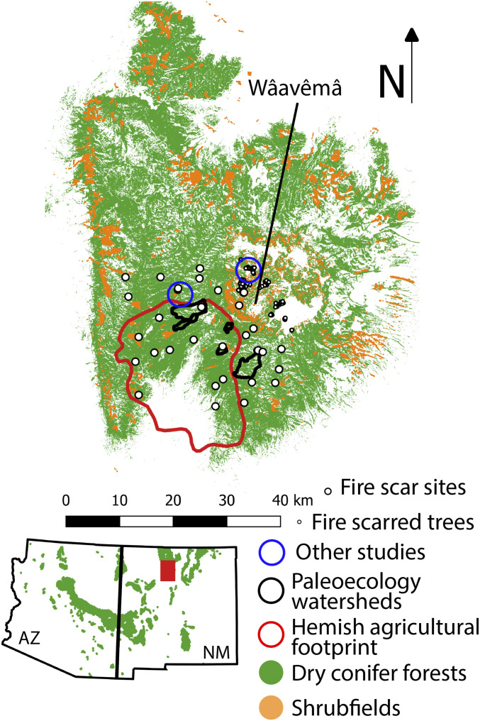
Location of the study area in the North American Southwest (red rectangle in Inset) with geoarchaeological localities, tree-ring localities and samples, and the Hemish agricultural footprint over the distribution of dry conifer forests and oak shrubfields in the Jemez Mountains. Wâavêmâ (Redondo Peak) is located at 35.87 °N, 106.56 °W.
The Jemez Mountains are the product of volcanism over the last 25 million y along the western margin of the Rio Grande rift (3031–32). The major physiographic features of the mountain range are the product of early Pleistocene eruptions at 1.6 and 1.2 Ma that created a large (20+ km diameter) central caldera (the Valles Caldera) and blanketed the surrounding landscape of older volcanic and sedimentary rocks with pyroclastic flow deposits up to 900-m thick (the Bandelier Tuff). A series of rhyolite domes within the caldera and a resurgent dome at the center (Wâavêmâ for Jemez people; Redondo Peak on US Geological Survey maps) developed after the last major eruption of the caldera, with youngest eruptions (El Cajete Pumice and Banco Bonito Rhyolite) occurring during the last glacial period (31).
Biogeographically, the Jemez Mountains and the adjacent Sierra Nacimiento to the west are at the southern extent of the Southern Rocky Mountains. Although vegetation also varies by slope aspect and soils, elevation generally determines local microclimates, which in turn determine vegetation composition. Low elevations (approximately 1,600 to 1,900 m) are characterized by Juniper savannas (Juniperus monosperma, Bouteloua sp.) grading into pinyon-juniper woodlands (1,900 to 2,100 m; juniper with Pinus edulis). Woodlands transition to ponderosa pine forests (Pinus ponderosa) at mid-elevations (2,100 to 2,300 m), and ponderosa pine forests transition to dry mixed conifer forests (2,300 to 2,600 m; ponderosa with Douglas fir [Pseudotsuga menziesii]) and mesic mixed conifer forests (2,600 to 2,900 m; Douglas fir with quaking aspen [Populus tremuloides], white fir [Abies concolor], and Southwestern white pine [Pinus strobiformis]) as moisture and plant productivity increase with elevation. At the highest elevations (above 2,900 m), are alpine spruce-fir forests (Picea engelmanii, Abies lasiocarpa) (33).
Prior to fire suppression, fire regimes varied by moisture, productivity, and vegetation type. At the lowest elevation, dry conditions generally limit fine fuel production, although fire regimes in pinyon juniper woodlands are still not well characterized (34, 35). In contrast, ponderosa pine forests have one of the best-known historical fire regimes in the world. Thousands of tree-ring samples across the region indicate that fires occurred every 3 to 15 y in southwestern ponderosa pine forests from at least 1700 to 1870 CE (36, 37). In the Jemez Mountains, this pattern of frequent surface fires also occurred in dry mixed conifer forests (19, 38), although there were undoubtedly small patches of crown fires within these forests as well (39, 40). Climate played an important top-down role in regulating “free-range” fire regimes by influencing the production and flammability of fuels (37, 41, 42). In surface fire regimes, fires tended to occur during dry years that followed 1 to 3 wet years that produced abundant and continuous fuels (43). Fires were less frequent at higher elevations as a result of increased fuel moisture, but were more likely to burn at higher severity when they did burn because of the abundant biomass, although this fire activity varied with climate conditions (44, 45).
The modern climate for the Jemez Mountains varies depending on elevation, slope aspect, and the local impacts of cold air drainage. For ponderosa pine elevations (approximately 2,100 to 2,300 m) on the Jemez Plateau, average annual precipitation is 500 mm, 40% of which falls in the months of July, August, and September during the annual summer monsoon (18). Average annual temperatures are 7.6 °C (average monthly temperatures between −2.1 and 18.3 °C). Most presuppression wildfires occurred during the arid foresummer of May and June, months that are typically warm and dry (average just 26-mm precipitation per month but average temperatures of 11.1 to 15.8 °C) (46). Lower elevations are warmer and drier, whereas higher elevations are cooler and more mesic. Tree-ring reconstructions of annual precipitation indicate that the area experienced great interannual variability (47). Regional megadroughts identified in continental-scale tree-ring networks were not always as severe in the Jemez Mountains as in other parts of the southwestern United States but severe droughts in the 1100s, 1200s, 1400s, and 1500s CE nevertheless characterize the paleoclimate record for the area (4748–49).
Native American use of the Jemez Mountains began in the late Pleistocene. The Cerro del Medio obsidian source (one of the rhyolite domes in the Valles Caldera) is only found within the central caldera of the Jemez Mountains (50, 51). Artifacts made from this obsidian have been found at Folsom archaeological sites elsewhere in New Mexico (approximately 12,600 to 12,200 cal BP) (5253–54), meaning that people were traversing the uplands of the Jemez Mountains for toolstone and probably also for hunting during the late Pleistocene. Jemez Cave, located within San Diego Canyon in the center of the Jemez Plateau, displayed a long record of Archaic period use (approximately 5500 BCE to 700 cal CE) as well as some of the oldest dated maize (Zea mays) in the Southwest (5556–57). Remains of animals common in the uplands were recovered throughout the Jemez Cave sequence, suggesting that occupants of the cave regularly used the surrounding forest-covered mesas for hunting (56).
Hemish people maintain oral traditions about their migration to the Jemez Plateau in antiquity. Patterns of alpine forest and meadow create the appearance of an eagle on the south face of Wâavêmâ (Redondo Peak). This eagle features prominently in the migration saga of Hemish people. The origin of Hemish clans and lifeways can be traced to southwestern Colorado, where degrading climate conditions encouraged Hemish people to migrate in search of more reliable water at the place of the Sacred Eagle. During the journey a small group moved ahead in search of the Eagle and to mark the way. Eventually the entire group settled on the Jemez Plateau to the southwest of the Sacred Eagle and Wâavêmâ (58, 59).
Recent chronometric work on domestic water control features and optically stimulated luminescence dates of ceramics from early pueblos on the Jemez Plateau point to the establishment of the Hemish settlements in the upland landscape in the 1100s CE (60, 61). The initial population was probably relatively low, given the paucity of evidence for early settlement, but grew to number in the thousands by the time the final out-migration from the Four Corners commenced with the Great Drought at the end of the 13th century. By the late 1400s, we know that populations numbered between 5,000 and 8,000 in an area of 475 km2, generating population densities of 10.5 to 16.8 people km−2. Hemish populations collapsed by as much as 87% in the 17th century due to introduced diseases and depredations of Spanish colonialism (62). During peak Hemish population, the cultural landscape included thousands of small dwellings that archaeologists refer to as “field houses” (63). We use the distribution of field houses to define the spatial extent of the area that was most intensively used by Ancestral Jemez communities, what we call the Hemish agricultural footprint.
With the archaeological and historical population reconstruction and a collection of more than 1,000 tree-ring fire-scar samples, patterns in the local (Hemish agricultural footprint) and regional (Jemez Mountains) fire regimes become evident. In the period before the Hemish population collapse (approximately 1500 to 1650 CE) fires were small but frequent (37, 62). This patchy fire regime created resistance to spreading fires and ultimately decoupled fire activity from the climate patterns that drove fire in dry conifer forests across the western United States (37). After the Hemish population collapsed, widespread, climate-synchronized surface fires characterized the entire Jemez landscape, just as they did historically for dry forests across the West, a period we refer to as the “free-range” fire period (37). Here we expand on this record with an ethnographic synthesis and a network of geoarchaeological records of variability in fire, vegetation, and herbivore abundance to generate 2,000-y records of dynamism and stability at an ancient WUI (1,100 y before settlement, 900 y since). Dynamic computer simulations provide further detail on the consequences of this land use history on vegetation, fuels, and fire intensity.
Interviews with tribal elders at Jemez Pueblo identified 27 fire and fuelwood uses at different spatial scales relative to the domestic, village, agricultural, and larger forest landscape (Fig. 2). These wood and fire uses (and others) were corroborated by elders from the Hopi Tribe, the White Mountain Apache Tribe, and Zuni Pueblo, all of whose ancestors lived in and intensively used ponderosa pine forests elsewhere in the Southwest of the United States, indicating that these patterns were probably general features of indigenous wood and fire use in the region. These myriad fire and fuel uses connect elements of the cultural and economic system to ecological systems across scales. For example, open landscape burning was not a feature of the domestic or village context. The major feature of human impacts at these geographic scales was driven by fuelwood collecting (removal of fuels from the landscape) to support controlled fire uses (e.g., for heating or cooking). Fire was viewed with great respect and caution by our tribal research participants, suggesting that indiscriminate fire use would have been subject to social sanction. Nevertheless, the ecological benefits of cultural burning were recognized. In the words of our Hemish collaborator, Paul Tosa, “Fire adds richness to the land.”
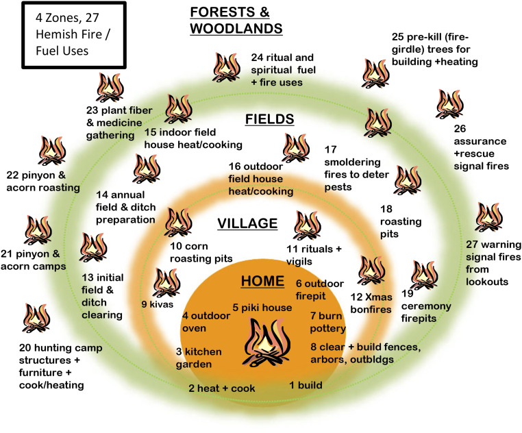
Conceptual map of landscape zones and 27 fire and wood uses for Hemish people.
In the agricultural landscape, fire use was utilitarian and targeted to specific places and purposes. Fire was used to establish and clear agricultural fields and irrigation features, as well as in controlled settings similar to village and domestic uses. Thus, the major features of human impacts in the agricultural landscape include both applied fire ecology in the service of agricultural production and fuelwood collecting to support contained uses of fire. In the forest and woodland landscape beyond (or between) agricultural areas, fire took on more varied roles. In these settings, fire may have been used to improve the productivity of wild plant harvesting areas (64), to process wild resources (65), to prepare trees for architectural use, perhaps to aid hunting (66), as well as for purposes associated with pilgrimage and ritual practices (6768–69). Because these uses are located further from the archaeological record of occupation and intensive use, and potentially more diffuse in their distribution, these fire practices are more difficult to distinguish from natural fires, although this makes them no less ecologically significant (70, 71). In summary, Hemish people manipulated both fire and fuels in woodland and forest contexts to satisfy the needs of particular activities in controlled and landscape contexts, but these varied geographically relative to features of the cultural landscape (72). They viewed fire-use with great respect and care but also appreciated the value of its ecological consequences when used appropriately.
Sedimentation rates and radiocarbon dates on reworked, older charcoal provide evidence for increased erosion of upland soils and deposition at the geoarchaeological localities. Fig. 3 plots periods of above average sedimentation (relative to late Holocene mean values) and deposition of reworked older charcoal for six stratigraphic locations (one locality has two records). Four of the six localities have their highest late Holocene sedimentation rates during the period of Hemish occupation. The other two have peak sedimentation rates that either overlap with this period (Banco Bonito 1) or date exclusively to the decades immediately after the Hemish population collapse (Monument Canyon 4) when agricultural fields would no longer have been maintained. Twenty-one of 24 reworked charcoal dates in the last 2,000 y also date to the period of Hemish agricultural use. Taking these data together, we find that the period of Hemish occupation of the uplands corresponds to peaks in upland erosion and sediment supply relative to the entire late Holocene. This is almost certainly related to agricultural clearing and use and shows up in accelerated eolian deposition elsewhere in the Jemez Mountains (73).
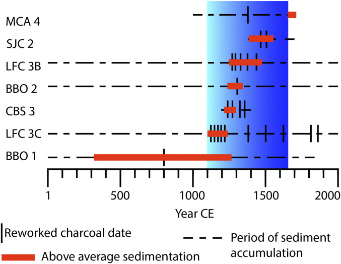
Plot of erosion and sedimentation histories for the past 2,000 y for six dated stratigraphic sections within or adjacent to the Hemish agricultural footprint. The graded blue area indicates the major period of agricultural settlement in the uplands of the Jemez Plateau between 1100 and 1650 CE. BBO, Banco Bonito; CBS, Cebollita Springs; LFC, Lake Fork, Canyon; MCA, Monument Canyon; SJC, Upper San Juan Canyon.
Charcoal records from these six localities (Fig. 4A) indicate that this enhanced erosion was also accompanied by enhanced fire activity. Scaled to the late Holocene, charcoal concentrations were at their highest level during the last 900 y, coincident with Hemish occupation (1100 to 1650 CE) and the free-range fire period that followed (37, 62). There was variability between localities but the pattern captured in the averaged record was present to some degree in all localities. Specifically, peak charcoal concentrations were first achieved between 1100 and 1300 CE before declining to average values. This charcoal peak during initial settlement and despite low population may be a product of concentrated fire use to clear and establish the agricultural landscape for the immigrating Hemish communities. Charcoal production may have declined thereafter as fire use shifted to agricultural maintenance and a shift to finer fuels that produce less charcoal rather than a decrease in burned area. The increase in charcoal after 1450 CE may indicate further population growth and the need to create more agricultural land to support the growing population. Charcoal concentrations increased further at 1650 CE, coincident with the major Hemish population collapse and the accumulation of fuels after the reduction of Hemish wood harvesting and fire management. Therefore, the free-range fire period may appear to have had unusually high fire activity for the late Holocene (based on charcoal abundance), but this probably reflects postabandonment fuel accumulation generating more charcoal (74).
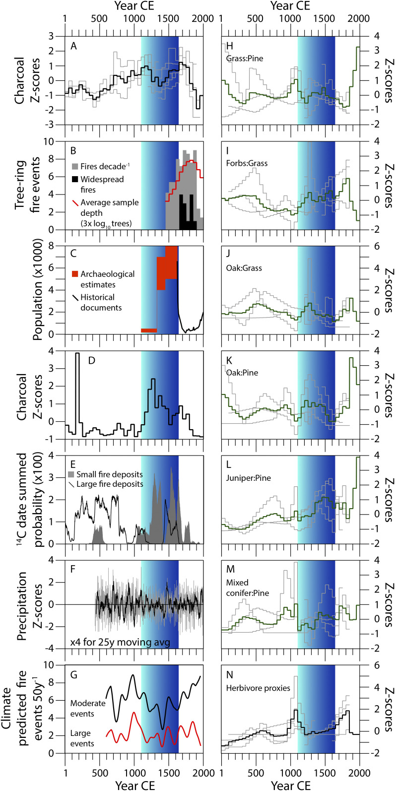
Stratigraphic and tree-ring proxies for fire, vegetation, and herbivore biomass compared with other local fire history studies, climate, and human population size from 1 to 2000 CE. Charcoal concentrations (A), pollen ratios (H–M), and herbivore proxies (N) from the Hemish footprint are plotted using 50-y bins of weighted averages of interpolated values for local time series and converted to z-scores relative to late Holocene (last 4,000 y) values (SI Appendix). Black (charcoal and herbivore proxies) or green (pollen) are averages of individual records (plotted as gray lines). Fire-scars (B) were plotted using 50-y sums for standardized comparison with the charcoal records. Population reconstructions (C) are based on our previous study (62) and plot the range of values used to parameterize our model simulations. Charcoal concentrations from Alamo Bog (38) were plotted in 50-y bins and converted to late Holocene z-scores using the same method as our charcoal records (D). Summed probabilities for postfire erosion were calculated in BCal (112) using data in Fitch and Meyer (40) (E). Standardized precipitation reconstructions (F) are from data in Touchan et al. (47). Climate modeled frequencies of surface fires (G) are from Roos and Swetnam (43).
Elements of this pattern were reproduced in tree-ring records from within the agricultural footprint and in a buffer area up to 10 km surrounding it. Prior to 1650 CE, fires were common but they were small. Not a single fire year from 1450 to 1650 showed scarring of more than 25% synchrony of all recording trees, despite a fading tree-ring record, which should mathematically increase the likelihood of higher synchrony values (Fig. 4B). However, after 1650 CE, widespread fires (scarring ≥25% of recording trees) became a regular feature of the fire regime. This is the free-range burning regime in which fires spread as widely as fuel continuity and weather conditions allowed (37). In both charcoal and fire-scar records, fire activity dropped to historical lows in the late 19th and 20th centuries.
This pattern of enhanced, low-severity fire activity during Hemish occupation is replicated in prior studies located within 10 km surrounding the Hemish agricultural footprint. At Alamo Bog, situated to the west of Wâavêmâ (Redondo Peak) in an area of ponderosa pine and dry mixed-conifer forest, charcoal concentrations were at high levels during peak Hemish populations and again after depopulation when local tree-ring records indicate frequent spreading surface fires (Fig. 4D) (38). Geomorphological investigations in an area of south-facing ponderosa pine forest and north-facing mixed-conifer forest just north of the Hemish footprint indicated a transition from thick postfire erosion deposits to predominantly thin postfire deposits after 1100 cal CE (Fig. 4E). These are interpreted as a shift in the balance from mixed-severity fires to increased frequencies of low-severity fires (40).
The evidence for increased, low-severity fire activity during Hemish occupation occurred when climate drivers for surface fire activity actually declined in frequency. No change in fire activity is clearly associated with acute or prolonged droughts of the 1200s, 1400s, or 1500s CE (Fig. 4F) (47). Low frequency variation in interannual patterns of wet–dry switching that are key drivers in surface fire regimes across the western United States (36, 37) were at relative minima during the period of Hemish occupation from 1100 to 1650 CE (Fig. 4G) (43). Major climate episodes, such as the Medieval Climate Anomaly (approximately 800 to 1300 CE) and Little Ice Age (approximately 1500 to 1850 CE) are not uniformly reflected in southwestern United States paleoclimate records (43, 75, 76) and do not bear any clear relationship to variability in fire proxies. Together, these data suggest that the enhanced fire activity during Hemish occupation was not driven by interannual, multidecadal, or centennial climate fluctuations; it was driven by Hemish land use. Furthermore, despite the potential for interannual and multidecadal climate to support more mixed or high severity fires in the 1400s and 1500s CE megadroughts, there is no evidence of any increase in fire severity prior to the late 20th century (60).
Pollen records were highly variable from locale to locale (SI Appendix), but standardized ratios of key pollen taxa reveal several shared patterns across the establishment, use, and depopulation of the Hemish agricultural landscape. Grass (Poaceae) pollen peaked in abundance right at initial settlement of the Jemez Plateau. Interpolation between samples suggests that this trend may have begun before settlement, but pollen samples dating to this interval were not available to confirm this (Fig. 4H). High grass contributions to the pollen record in the 20th century were likely an artifact of the shrinking area of a single bog context that had grass locally becoming abundant in areas previously covered by sedge (Cyperaceae). In contrast, arboreal taxa from mixed conifer forests (Abies, Picea, Pseudotsuga) clearly were at high levels for centuries before settlement, dropped to low levels during initial occupation 1100 to 1350 CE, but returned to higher levels after Hemish depopulation (Fig. 4M). Juniper (Juniperus), oak (Quercus), and forbs (primarily Amaranthaceae and Asteraceae) all increase in relative abundance during occupation (Fig. 4 J–L). The latter suggests an increase in abundance of disturbance-adapted taxa. The former two may reflect greater patch heterogeneity created by anthropogenic burning of many small patches, thereby protecting more fire-sensitive woody taxa (77), although oak also vigorously resprouts after fire. The steep rise in juniper and oak in the 20th century likely reflected woody encroachment and infilling with fire suppression, although some of this may reflect environmental rebound from centuries of wood harvesting (33).
Another feature of initial settlement was the increase in herbivore proxies coincident with the increase in charcoal and grass pollen around 1100 CE (Fig. 4N). The increase in herbivore proxies between 1100 and 1300 CE is replicated across four different localities and two different proxies: The dung fungus Sporormiella (78) and herbivore fecal stanols (79). This spike in herbivore proxies was short lived and ceased by the time that Hemish populations numbered in the thousands (Fig. 4 C and N). Herbivore proxies were not abundant again until the late 19th century when more than 100,000 domestic cattle and sheep grazed in the Jemez Mountains (80). Although much of the anthropogenic burning during initial settlement was to establish the agricultural landscape, the correlations between grass, charcoal, and herbivore proxies indicate that large herbivores also benefitted from these ecological changes despite ongoing hunting pressure (81). Some of this burning may have been to purposefully improve habitat for large game, which were economically important in the area since at least the Archaic period (56). After 1300 CE, with a Hemish population in the thousands, hunting pressure would have been much greater, driving down the local abundance of large game (33, 81).
We simulated a range of land-use scenarios, including a “null” scenario of no human inputs, scenarios with different intensities of fuelwood-use only (scaled to population estimates from the archaeology), and intensive use scenarios that included fuel and structural wood use, human-augmented ignitions, and clearing and burning agricultural land (scaled to population estimates) to assess what activities and magnitude of human impact would have been necessary to create the fire and vegetation patterns seen in the paleoecology. Compared to the null scenario, a scenario of intensive wood, fire, and land use scaled to a conservative population estimate produced significantly (P ≤ 0.05) higher overall burned area, a smaller mean and range of fire sizes, lower tree density, and lower tree mortality than the null scenario for the period of peak Hemish occupation used in the model (1340 to 1630 CE) (Table 1). Reduced tree mortality suggests that the anthropogenic fire regime of many, small, low-intensity fires across the landscape reduced forest vulnerability to fire-caused mortality, thus maintaining resilience even though the overall burned area was larger than any of the other chronological phases (Fig. 5).

| Phase | Area burned | Firesize | Intensity | Tree mortality |
| 1200–1330 | 0.0011 | 0.4489 | 0.0305 | 0.0595 |
| 1340–1630 | 0.0000 | 0.0000 | 0.0000 | 0.0000 |
| 1640–1680 | 0.2962 | 0.6158 | 0.0015 | 0.1264 |
| 1690–1900 | 0.1236 | 0.6219 | 0.7995 | 0.0005 |
Statistical comparison of four key fire metrics—fire intensity, fire size, tree mortality, and total area burned—for null and a high-intensity land-use scenario [LP, SF, HIA scenario; low population, low fuelwood use (1 cord/person/year), natural ignitions augmented by 0.30%/person/year, agriculture at 4 acres/person/year, live tree harvest at 1 tree/person/year] (SI Appendix, Table S15) in our simulations. Bold numbers indicate significant differences between scenarios for each population phase at the α < 0.05 level for P values using Welch’s unequal variance two-sample t tests of differences in mean values.
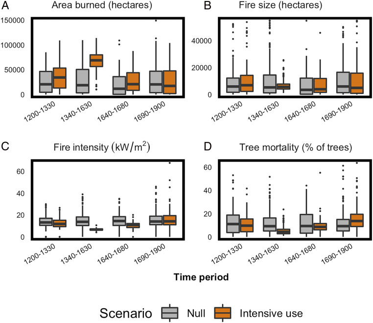
Dynamic vegetation and fire modeling of null and intensive land-use scenarios. Modeling indicates that area burned increased with Hemish fire management, even when populations numbered in the hundreds (A). The increase in area burned, however, was driven by increases in ignitions, as mean fire sizes were significantly smaller and less variable under Hemish management during peak populations (Table 1) (B). This increase in fire frequency, decrease in fire size, and synchronous wood harvesting and tree-thinning meant that fire intensity (C) and tree mortality (D) were significantly lower during Hemish management, indicating that forests in the Hemish footprint would have been more resilient to climate variation and extreme fire weather.
Although frequent, low-severity surface fires were predominant throughout the late Holocene on the Jemez Plateau, multiple fire regimes characterized the ancient WUI. Fires during initial settlement may have been larger and higher intensity (due to increased fuel loads) to create the openness of the agricultural landscape, 1100 to 1300 CE. Maintenance of the cultural landscape after 1300 CE may have reduced fire intensity and fire size in the agricultural landscape but expanded fire use to larger parts of the Jemez Mountains to support wild plant collecting and ritual activity (Fig. 2). The benefits of fire on habitat of preferred large game species may have pushed fire use in hunting further away from the settled parts of the Jemez landscape as well. The population collapse and rebound of fuels in the 17th century favored widely spreading surface fires that reduced patch heterogeneity that had been supported by the previous 500 y of Native American fire management. Throughout this sequence, fire regimes were dominated by surface fires that differed primarily in their frequency, size, fuels, and location.
Importantly, the Hemish case indicates that smoke and fire are ubiquitous features of a sustainable WUI. In fact, fire and smoke were almost certainly perennial features of the Jemez Plateau during Hemish occupation. The low fire intensities and low rates of pyrogenic biomass consumption (Fig. 5) mean that smoke conditions in the past may not have been as severe as they are today after more than a century of fire suppression and fuel accumulation (60). Charcoal deposition alone suggests that this fire-free period in the 20th century is unusual for at least 1500 y (Fig. 4A), and perhaps much longer (38).
But these patterns cannot be generalized uniformly across the Hemish landscape, let alone across the entire mountain range (82, 83). In the immediate vicinity of the villages (<100 m), fire was almost certainly absent due to collection and trampling of fine fuels by hundreds to thousands of feet in daily traffic. Note too that ethnographic reports of fire uses in the domestic and village contexts did not include landscape applications. The areas up to 200 m from Pueblo villages were apparently devoid of living trees during occupation (62, 84). Harvesting trees for fuelwood and architecture would have maintained open forest stands surrounding the village clearings even in the absence of fire. This tree thinning would have been most intensive near the pueblos and declined in intensity with distance, further reducing the fuel hazard in the vicinity of the villages and creating spatial heterogeneity in forest structure. Fires did burn within 1 km of inhabited villages, as fire-scar records indicate (84), so the exclusion of fire in the immediate vicinity of pueblos was a highly localized phenomenon.
Within the agricultural landscapes of active and fallow fields, field houses, trails, and patches of intact vegetation, fires were probably very small (approximately 100 ha or less) and limited to particular fields or forest patches. At larger spatial scales, Hemish fire uses may be difficult to distinguish from nonhuman, frequent surface fires (70, 82). Nevertheless, within 10 km of the intensively used agricultural landscape, patchy, frequent, low-severity, anthropogenic surface fires were detectable in the fire-scar network, as well in geomorphic (40) and sedimentary charcoal records (38). This means that the area influenced by Hemish fire management covered at least 840 km2 of dry conifer forest, an area larger than the city of Chicago, IL (606 km2). Synthesis of tree-ring records across the entire Jemez Mountains even suggests that the small, patchy fire regime that characterized peak Hemish occupation was present across the mountain range, up to 2,180 km2 of dry conifer forests (37). The character of human impacts was scale-dependent relative to particular settlements and land-use activities but the emergent consequences of these impacts were felt at the landscape scale. The paleoecological signatures of these impacts were only recognizable by sampling at scales appropriate to the different land-use activities (83) and by explicitly negotiating the subtlety of human impacts on an already fire-rich landscape (7071–72).
The collection of woody fuels for controlled combustion in heating, cooking, and ceremonial contexts would also have created scale-dependent impacts on surface fuel loads, stand densities, and tree canopies, with the greatest impacts near villages and fieldhouses. The total impact on fuel loads would have reduced fire intensity and smoldering, potentially reducing the severity of landscape fires. Our modeling suggests that this would have been the case even in lower population scenarios (Fig. 5). Optically stimulated luminescence dating of ceramics deposited on the surface during Hemish occupation indicate that fire intensities during Hemish management and during the free-range fire period that followed never reached levels seen in modern prescribed fires (60). Further indirect evidence that Hemish wood and fire use reduced the risks of crown fires may be in the distribution of Gambel oak (Quercus gambelii) shrubfields. Shrubfields, a pyrogenic alternative stable state of ponderosa pine and dry mixed-conifer forests (39), make up 4.7% of the area of dry conifer forests in the Jemez Mountains. Within the Hemish agricultural footprint, however, shrubfields make up only 2.2%, whereas outside of the footprint, shrubfields make up 5.1% of Jemez Mountains forested area. Despite the occurrence of protracted and acute megadroughts in the 15th and 16th centuries, there is no evidence in our stratigraphic records of increases in fire intensity or fire severity. Interannual climate patterns that drove extensive (up to 100,000 ha) surface fires in the free-range fire period (18) had little impact on fire activity under Hemish fire management, which seems to have effectively decoupled fire activity from climate drivers (37).
The Jemez ancient WUI obviously contrasts with modern WUI in the American West in ways that make the ancient WUI an imperfect analog for modern conditions. The economic, technological, and political differences are irreconcilable but they do not obviate the relevance of the ancient WUI for modern problems. The cultural contrasts between ancient and modern WUI highlight opportunities to cultivate more resilient communities by supporting particular cultural values. Two of the important characteristics of the Jemez ancient WUI are: 1) That it was a working landscape, in which properties of the fire regime were shaped by wood, land, and fire use that supported the livelihoods of the residents; and 2) that there was much greater acceptance of the positive benefits of fire and smoke. We emphasize that these are malleable cultural features, because reshaping western United States culture by learning from indigenous cultural values may be critical for building adaptive and transformative resilience in modern communities (26, 28, 85, 86). Learning to value the positive benefits of fire and smoke and to tolerate their presence will undoubtedly be critical to WUI fire adaptations. Furthermore, the ancient WUI highlights two key processes that may make modern WUI more resistant to extreme fires: 1) Intensive wood collecting and thinning, particularly in close proximity to settlements; and 2) using many small, patchy fires annually (approximately 100 ha) rather than using larger burn patches (thousands of hectares) to restore fire and reduce fuel hazards, particularly closer to settlements. Many WUI communities—especially rural and Indigenous communities—rely on domestic biomass burning for heat during the winter. Public/private–tribal partnerships to thin small diameter trees and collect downed and dead fuel for domestic use could have dual benefits for the community by meeting energy needs and reducing fuel loads. Tribal communities that have deep histories in a particular forested landscape may be ideal partners for supervising such a program (87). Lessons from the Jemez ancient WUI also suggest that federal and state programs to support prescribed burning by Native American tribes, WUI municipalities, and private land owners would provide equal benefit to modern communities (88). It is imperative that we understand the properties and dynamics of past human–natural systems that offer lessons for contemporary communities (8990–91). The Jemez ancient WUI is one of many such settings (72, 9293949596–97) where centuries of sustainable human–fire interaction offer tangible lessons for adapting to wildfire for contemporary communities.
We used light detection and ranging (LiDAR) to calculate rubble volumes for pueblos occupied approximatelyy 1500 CE and converted these to population estimates using regional calibration datasets. For occupations prior to 1500 CE, we used room count estimates (98) to scale population estimates based on our LiDAR calculations. These numbers were used for the purpose of modeling per capita land use in the computer simulation but are the subject of ongoing archaeological investigation. The archaeological methods used here are elaborated upon in our prior publication (62).
Our collaborative ethnographic research was based in a partnership with the Pueblo of Jemez, with the participation of the Hopi, White Mountain Apache, and Zuni tribes, and included active involvement of more than 20 tribal research participants. One of the principal goals of our ethnographic research was to document the cultural and behavioral factors involved with the ignition and suppression of forest fires. To do this, we collected semistructured interview data with members of each partnering tribe. Our interviews collected information about the use of fire in agriculture, grazing, and cultural practices, and how the use of trails and the harvesting of wood for fuel and construction would affect fire behavior. We also asked tribal members to identify healthy forest structure, and to comment on their personal experience with forest fires.
At Jemez Pueblo, we focused on historical information related to the project area by interviewing the descendants of the people who lived in the forested uplands until the 18th century. Our research with Hopi, the White Mountain Apache, and Zuni collected generalizing information about fire and wood use from people who live in and use other forested environments in the Southwest. Most of our interviews at Jemez were conducted in the Towa language by Chris Toya, Paul Tosa, and John Galvan, allowing for research participants to protect esoteric cultural knowledge that would be inappropriate to share. Translated portions of transcribed interviews were analyzed using the NVivo qualitative analysis software.
To reconstruct historical fire frequency over the last four to five centuries, tree-ring fire scars were collected from 42 sites and an additional 126 individual trees within and in the 10 km adjacent to the Hemish agricultural footprint (n = 491 total fire-scarred trees). Partial or full cross-sections were taken with a chain saw from the lower bole of living and dead fire-scarred trees. Fire-scar sites were selected to be either adjacent to Hemish archaeological sites (37) or were part of the Jemez fire-scar network (18). We use a restricted subset of tree-ring samples from the 1,654 samples used in Liebmann et al. (62) and Swetnam et al. (37). The subset used here have undergone another layer of quality control and reproducibility (18). Sites consist of 8 to 20 fire-scarred trees in small (1 to 2 ha) areas. Individual trees were sampled along the forest-grassland ecotone in the Valles Caldera National Preserve (42). Cross-section samples from all trees were prepared for microscopic examination by surfacing with a belt sander and grits up to 400. All tree rings were cross-dated and the year of fire scars was determined using standard methods (99). The number of fires per half century was calculated using all fires recorded by any trees. Widespread fires were defined as scarring ≥25% of recording trees. After initial scarring, which opens the bark and increases the probability of recording subsequent fires as scars, a tree became a “recording tree” in the dataset.
Six stratigraphic locations from within and adjacent to the Hemish agricultural footprint were analyzed to infer patterns of fire activity, vegetation change, and herbivore abundance over the last 2,000 y (Fig. 1). Charcoal and bulk sediment samples were radiocarbon-dated to generate chronologies of sediment accumulation, soil formation, and stability, and to generate quasi-time series of charcoal, pollen, and other proxies. All proxies were compared to the archaeological population estimates (62), tree-ring climate reconstructions (43, 47), and other local paleofire studies (38, 40) in half-century intervals over the past two millennia. We cored or trenched sedimentary basins in terrestrial and palustrine contexts within or adjacent to the Hemish agricultural footprint. Soil and lithostratigraphy were described in the field using standard terms and samples were collected at 2, 5, or 10 cm continuously for analysis, depending on stratigraphy. Textural characteristics of gravel percentage, and percentages of sand, silt, and clay were measured to assess depositional impacts on charcoal variability. Charcoal concentrations were estimated by chemical digestion and loss on ignition (terrestrial localities) (100) or macroscopic sieving and counting (125 µm; wetland contexts) (101). Radiocarbon dates on charcoal or, rarely, bulk soil or sediments provided age control for the strata and were used to estimate sedimentation rates and to model age–depth relationships. Bulk samples were processed for pollen using standard methods and counted in comparison to regional databases. Lipid biomarkers were extracted using solvents and measured via GC-MS to identify and quantify stanols. Charcoal, pollen, and herbivore proxies were interpolated and averaged to 50-y bins and converted to z-scores using the late Holocene (last 4,000 y) mean and SD for each record. To standardize the pollen records, which vary considerably from locality to locality, ratios of key pollen categories to grass (for understory plants, such as Quercus and forbs) or pine pollen (for arboreal taxa) were calculated prior to standardizing the variance as late Holocene z-scores. Further details on geoarchaeological methods can be found in SI Appendix.
We modeled ancient, coupled human and natural fire and forest dynamics using the spatially explicit, mechanistic ecosystem process model FireBGCv2 (Fire BioGeoChemical model v2) (102103–104). Model details are described in Keane et al. (104) and in SI Appendix. We constructed scenarios that described modifications to fuel structure, fire ignitions, and forest structure resulting from fuelwood collection by ancient people, human-caused fire ignitions, agriculture, and timber harvest. For comparison, we also designed a scenario that describes a null model that excludes human–landscape interactions and where vegetation growth and structure and disturbance dynamics are driven by climate alone. We modeled fire and forest dynamics over a 900-y time period that included a 200-y initialization period in which no human activities were simulated, a subsequent 500-y period of modeled human land and fire use, and a final 200-y free-range fire period. Factors included in scenarios were population size [derived from archaeological reconstructions in Liebmann et al. (62) and above], fuelwood harvest levels, augmented human ignitions, (0.15% and 0.3% of the population, respectively, estimated from refs. 105, 106) and agricultural use [clear cut and burn 0.4 ha per person and 1.6 ha per person, respectively (107, 108)]. In some scenarios we included timber harvest at the rate of one tree per person per year for architectural use (SI Appendix).
We thank the Jemez Tribal Council for authorizing ethnographic, archaeological, and paleoecological research on their ancestral landscapes; the Jemez Tribal Historic Preservation Office and Department of Natural Resources for facilitating our work; and the tribal historic preservation offices of the Hopi, White Mountain Apache, and Zuni tribes for their involvement. Former Governor of Jemez Pueblo, Paul Tosa, was instrumental to the success of the ethnography project. Chris Toya and John Galvan of the Jemez Natural Resources Division provided key support to the ethnographic, archaeological, and modeling projects. Mike Bremmer of the Santa Fe National Forest and Bob Parmenter and Ana Steffen of the Valles Caldera National Preserve provided institutional support of our work on federal lands. This research was financially supported by an NSF Dynamics of Coupled Natural-Human Systems Award GEO-1114898 (to T.W.S., T.J.F., R.A.L., M.J.L., and C.I.R.). Any use of trade, firm, or product names is for descriptive purposes only and does not imply endorsement by the US Government.
Pollen and charcoal data have been deposited in the Neotoma Paleoecology Database, https://www.neotomadb.org/. Tree-ring records are available in the International Tree-Ring Data Bank, https://www.ncdc.noaa.gov/data-access/paleoclimatology-data/datasets/tree-ring.
1
2
3
4
5
6
7
8
9
10
11
12
13
14
15
16
17
18
19
20
21
22
23
24
25
26
27
28
29
30
31
32
33
34
35
36
37
38
39
40
41
42
43
44
45
46
47
48
49
50
51
52
53
54
55
56
57
58
59
60
61
62
63
64
65
66
67
68
69
70
71
72
73
74
75
76
77
78
79
80
81
82
83
84
85
86
87
88
89
90
91
92
93
94
95
96
97
98
99
100
101
102
103
104
105
106
107
108
 Native American fire management at an ancient wildland–urban interface in the Southwest United States
 Facebook
 Twitter
 Linkedin
 Whatsapp
